


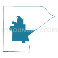
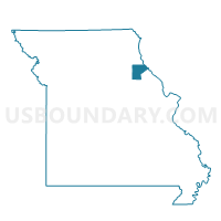
Center Voting District, Ralls County, Missouri
About
Outline

Summary
| Unique Area Identifier | 609505 |
| Name | Center Voting District |
| County | Ralls County |
| State | Missouri |
| Area (square miles) | 99.62 |
| Land Area (square miles) | 98.71 |
| Water Area (square miles) | 0.91 |
| % of Land Area | 99.09 |
| % of Water Area | 0.91 |
| Latitude of the Internal Point | 39.49253780 |
| Longtitude of the Internal Point | -91.53773540 |
Maps

Graphs
Select a template below for downloading or customizing gragh for Center Voting District, Ralls County, Missouri


Neighbors
Neighoring Voting District (by Name) Neighboring Voting District on the Map
- Hassard Voting District, Ralls County, MO
- Liberty Voting District, Ralls County, MO
- New London Voting District, Ralls County, MO
- Peno V Voting District, Pike County, MO
- Perry Voting District, Ralls County, MO
- Rensselaer Voting District, Ralls County, MO
- Spencer TU Voting District, Pike County, MO
Top 10 Neighboring County Subdivision (by Population) Neighboring County Subdivision on the Map
- Clay township, Ralls County, MO (2,765)
- Spencer township, Ralls County, MO (1,818)
- Salt River township, Ralls County, MO (1,279)
- Center township, Ralls County, MO (928)
- Peno township, Pike County, MO (910)
- Spencer township, Pike County, MO (798)
- Saline township, Ralls County, MO (781)
- Jasper township, Ralls County, MO (562)
Top 10 Neighboring Place (by Population) Neighboring Place on the Map
Top 10 Neighboring Unified School District (by Population) Neighboring Unified School District on the Map
- Bowling Green R-I School District, MO (11,119)
- Monroe City R-I School District, MO (5,433)
- Van-Far School District, MO (5,416)
- Ralls County R-II School District, MO (5,269)
Top 10 Neighboring State Legislative District Lower Chamber (by Population) Neighboring State Legislative District Lower Chamber on the Map
Top 10 Neighboring State Legislative District Upper Chamber (by Population) Neighboring State Legislative District Upper Chamber on the Map
Top 10 Neighboring 111th Congressional District (by Population) Neighboring 111th Congressional District on the Map
Top 10 Neighboring Census Tract (by Population) Neighboring Census Tract on the Map
- Census Tract 4603, Pike County, MO (5,984)
- Census Tract 4702, Ralls County, MO (3,801)
- Census Tract 4703, Ralls County, MO (3,123)
Top 10 Neighboring 5-Digit ZIP Code Tabulation Area (by Population) Neighboring 5-Digit ZIP Code Tabulation Area on the Map
- 63401, MO (22,067)
- 63382, MO (4,897)
- 63456, MO (4,271)
- 63459, MO (4,153)
- 63462, MO (1,458)
- 63436, MO (1,155)
- 63339, MO (1,145)
- 63441, MO (1,121)